
Hot Press News
- Forbes-Listed Digital Marketing Agency Eflot Outlines a Growth Playbook for Chennai Brands
- Top Two Podcast brings meaningful, inclusive conversations to India’s growing podcast culture
- Dream Aura India Launches Complete Participant Guide for Aspiring Beauty Pageant Contestants
- STUDDS Accessories Ltd. Launches the Trooper Trail Helmet in India
- Whiskas Introduces Adult Cat Food Ocean Fish 3kg to Support Everyday Feline Nutrition
- Infinix Expands NOTE 60 Pro Lineup with Two New Colour Variants
- SysInfoTools Launches Advanced Microsoft 365 Tenant-to-Tenant Migration Tool for Enterprise
- Tackle Smart Sports Advances Safer Football Training Through Science-Based Coaching Programs for Young Athletes in Texas
- Jagannath Temple Ahmedabad Strengthens Gujarat's Spiritual Tourism with Historic Heritage, Sacred Rath Yatra, and Timeless Devotional Traditions
- Hollywood Filmmaker Govind K. Saji Conducts Inspiring Workshop at AAFT School of Cinema
- Mindbowser Elevates Manisha Khadge as COO Amid Continued Growth
- iCallify Releases AI-Driven Inbound Call Center Platform
- Seasia Infotech Highlights How New York Businesses Are Adopting Custom Software Solutions
- Union Minister G. Kishan Reddy Announces India Mining Week 2026 to be held in November 15–17
- VR Corporatenext has launched SISTEMA INDUSTRIA ITALIA
 Mail to a Friend Mail to a Friend |
|
 |
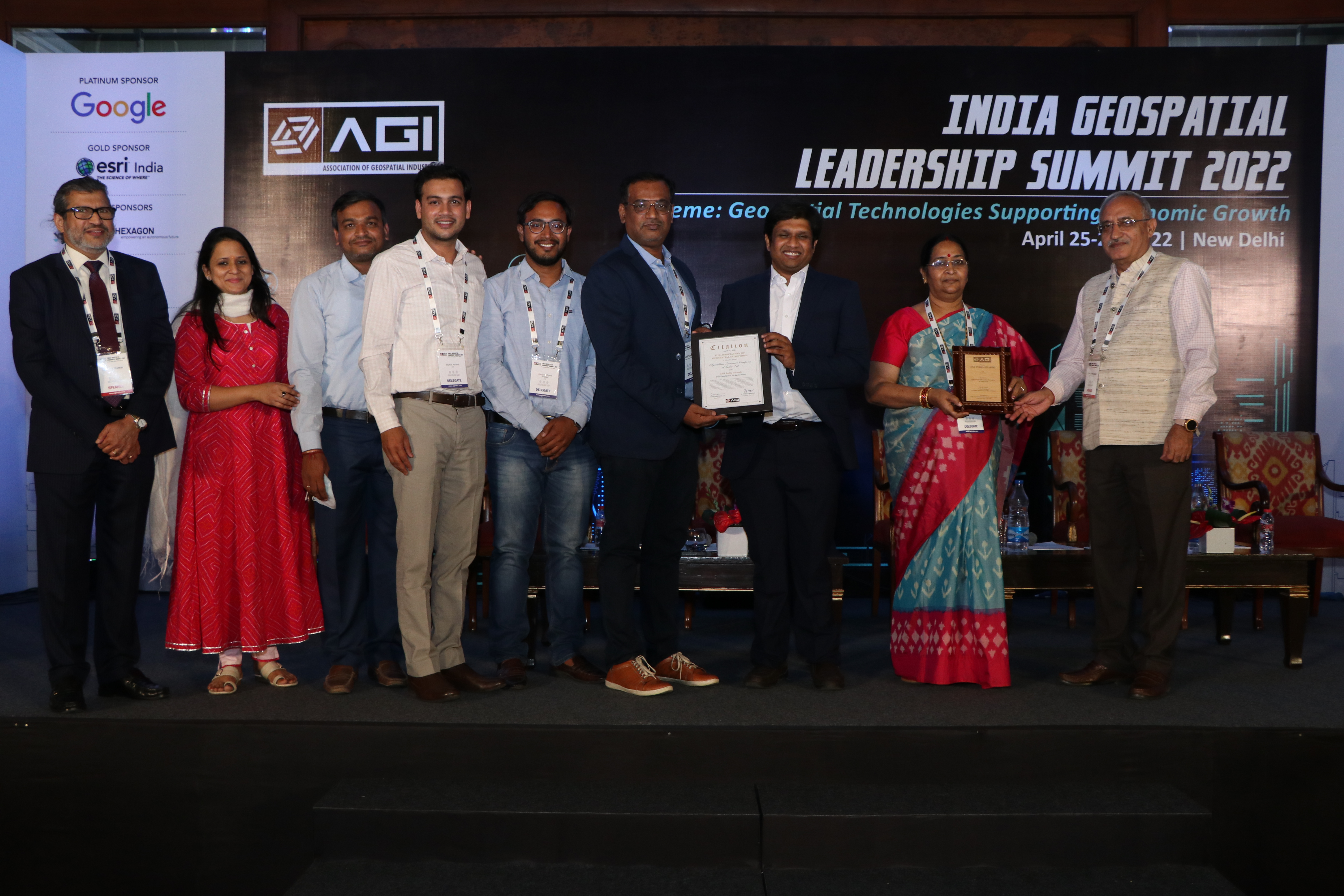
AGI India Awards Recognize Exemplary Work across Major Economic Sectors
2026-07-16 12:13:13
Events / Trade Shows
1849
April 25, 2022, New Delhi, India: On the sidelines of the ?India Geospatial Leadership Summit (IGLS) 2022? being held in New Delhi on 25-26 April 2022, the Association of Geospatial Industries announced the AGI India Awards. The awards were conferred for exemplary work done in Land Administration, Water Resources, Mapping for Development, Defence & Security, Agriculture, Urban Management, Disaster Management, Governance, and Infrastructure Development sectors. Their announcement at IGLS 2022 ? the Geospatial industry?s annual conclave ? was aimed at encouraging the use and adoption of innovative geospatial technologies for projects with tangible social and economic outcomes.
AGI India received 34 nominations from various central and state government agencies, Geospatial private sector companies, and academia under various categories and covering different fields and perspectives. These nominations were evaluated based on the size of the project, innovative use of Geospatial Technologies, the impact of the project, and its outcomes. They were assessed by a distinguished and independent jury, headed by Dr. Shailesh Nayak, Director, NIAS, and Dr. V. K. Dadhwal, Indira Gandhi Chair Professor of Environmental Science, NIAS & Former Director, NRSC.
On the occasion, Mr. Agendra Kumar, President of the Association of Geospatial Industries said, ?Geospatial technologies and content provide analytics and insights required for informed decision-making, implementation, and monitoring of government programs. Various economic sectors are using Geospatial intelligence to understand 'where' is the effort required, 'how' resources are being used, 'when' changes occur, and 'what' impacts they produce. The AGI India recognizes the accomplishments of various government organizations through exemplary use of geospatial data and technologies. Geospatial technologies and data produce very high economic value and help in job creation at all levels. With the 12.8% CAGR growth projection for this sector and forecasted economic value creation to the tune of INR 63,100 crores by 2025 as per the Geospatial Artha Report, continued efforts by the government and the industry are required for taking India towards a 5 trillion-dollar economy. I congratulate all the winners and appreciate their remarkable efforts towards driving the nation?s economic growth on the pillars of innovation and sustainability.?
Here are the?award?categories and list of winners:
UNIQUE LAND PARCEL IDENTIFICATION NUMBER (ULPIN) & INTEGRATED LAND INFORMATION MANAGEMENT SYSTEM (ILIMS) FOR LAND ADMINISTRATION
The ULPIN and ILIMS projects were conceptualized under the Digital India Land Records Modernization Programme (DILRMP) by the Department of Land Resources, Ministry of Rural Development, Government of India, as modern advancements to the programme. While the primary objective of the ULPIN project is to generate new land records and update existing ones based on the mirror principle, where cadastral records mirror the ground reality, the ILIMS aims at improving real-time land information, optimizing resources, and assisting in policy & planning. DILRMP uses a combination of Remote Sensing, Satellite Imagery, Surveying & Mapping, Positioning Technology, Hybrid Aerial Photography with Ground Truthing, and GIS. As a result of freely accessible data, there is a substantial reduction in land disputes, more accountability in land governance, greater accuracy in survey/resurvey works, cost and time savings, and more efficient workflows.
NAMAMI GANGE (PHASE 1 & 2) FOR WATER RESOURCES
Guided by a holistic approach, the focus of the National Mission for Clean Ganga?s flagship programme - Namami Gange - has been on the riverine ecosystem, including components such as pollution abatement, solid and liquid waste management, biodiversity, afforestation, wetland conservation, agribusiness, groundwater management, and so on. Four pillars of interventions - Nirmal Ganga (Unpolluted Flow), Aviral Ganga (Unrestricted Flow), Jan Ganga (People River Connect), and Gyan Ganga (Research and Knowledge Management) ? have been identified and implemented for the restoration, conservation, and rejuvenation of River Ganga. Technologies like LiDAR, GIS, positioning, and drones were used for monitoring river pollution, policy development research, water resource management, spatial planning, basin management, and mapping of river corridors, water bodies, biodiversity and resources, aquifers, climate scenarios, and spring rejuvenation.
NATIONAL IMAGE WEB SERVICE & BHARAT MAPS
Bharat Maps by the National Informatics Centre (NIC) supports the Indian government?s Digital India initiative that is transforming India into a digitally empowered society. A multi-layer integrated GIS Platform was created to provide seamless access to data as a service for various Mission Mode projects and e-gov divisions of NIC at the Central and State level. It uses 1:50,000 scale reference data from Survey of India, ISRO, FSI, RGI, and others, comprising 23 layers of spatial information. As part of Bharat Maps, NIC created a national image web service of natural color products and imagery published as a map service to Bharat Maps. Bharat Maps has resulted in several benefits for government departments, including resource optimization, workflow improvement, cost/time saving, etc.
CRIME AND CRIMINAL TRACKING NETWORK & SYSTEMS FOR INTERNAL SECURITY
With an aim to facilitate the mapping of various types of crime data for both citizen and departmental access, the UP Police Technical Services undertook the comprehensive CCTNS project. A state-of-the-art mobile application was developed that enables simplified analysis of crimes across zones, which in turn helps in effectively planning countermeasures. Nearest police officials are automatically detected during any incident, along with relaying the frequency at which they can reach the crime spot. All rungs of the police system, up to the DG level, can access crime-related insights and analytics with a single click.
CROP INSURANCE, PRADHAN MANTRI FASAL BIMA YOJANA, FOR AGRICULTURE
Pradhan Mantri Fasal Bima Yojana: Crop Insurance is an integrated IT solution and a web-based ecosystem to provide speedy insurance services to farmers. It facilitates in compensation of farmers for damages to their crops. Agriculture Insurance Company of India Limited used Artificial Intelligence-based Digital Image processing and classification for automated analytics of crop health, density, acreage and condition, accurate change detection, classification, crop insurance, watershed, irrigation, planting, etc. through satellite & drone imagery, and on the fly heat/density and spatial interpolation on existing geotagged information. These solutions have resulted in timely claim settlement of farmers, insurance for farmers, development of digital records of crop acreage, yield, classification, growth, etc.
GIS SINGULARITY ? PUNJAB FOR URBAN MANAGEMENT
The Integrated Command and Control Centre (ICCC) at Punjab Municipal Infrastructure Development Company (PMIDC) is the GIS backbone based on which multiple ground-breaking e-Governance interventions have been designed. Traditional geospatial techniques were used, integrating them with data coming from Management Information Systems, drone maps, mobile applications, chatbots, and more. In the end, a layer of intelligent AI/ML analytics was built to enable the usage of select data points for effective decision-making. An anonymized version is also made available to the public to maintain transparency. The system relies on creating data interoperability in siloed data sets, thereby, creating long-term savings on cost and one reliable truth. It has resulted in significant benefits, including increased revenue from property tax, Covid19 management, AMRUT cities water networks management, and Slum Proprietary rights with Basera.
FOREST FIRE MONITORING & ANALYSIS FOR DISASTER MANAGEMENT
Karnataka State Remote Sensing Applications Centre (KSRSAC) used remote sensing sensors to detect a total of 3,98,774 forest fires since November 2020. Satellite-based remote sensing technology and GIS tools were used effectively for better prevention and management of fires for creating a dynamic information system including an early warning mechanism for fire-prone areas, monitoring fires on a real-time basis, and estimating burn scars. The best available satellite imagery/UAV technology was deployed to aid active fire mitigation efforts in lesser time and monitor regrowth patterns. Data was prepared, collated, and disseminated from far and near for use by the Karnataka Forest Department and other concerned departments of the Government of Karnataka.
MahaBHUMI FOR GOVERNANCE
The Maharashtra Remote Sensing Applications Center (MRSAC), Nagpur, conducted a Large-Scale Mapping project at 1: 2000/4000 scale for the entire state, including digital elevation model and ortho mosaic generation along with mapping of various resources. All outputs are being shared with all State Government departments and will further be published for government use. The project is laying the foundation for the Spatial Data Infrastructure (SDI) for the state of Maharashtra in the form of a Geo-Portal in alliance with beneficiary departments. This integrated SDI will act as a Decision Support System for the State Government, eliminating duplication efforts, saving costs and time, and improving workflows.
MONITORING OF NHAI ASSETS & CONSTRUCTION FOR INFRASTRUCTURE DEVELOPMENT
As a robust solution for monitoring its construction projects, operations, and various assets, the National Highways Authority of India (NHAI) deployed aerial mapping & videography, photogrammetric ortho imaging, land audits, and 3D land mapping using drones. UAVs were used for data capture of National highways and toll plazas, and this data was interlaced with timestamps, geographic coordinates, structural information, and dynamic chainage. The progress was monitored at monthly intervals to check their alignment with various NHAI Guidelines dictating Rights of Way for greenfield and under construction routes and to identify encroachments, land issues, blackspots, and hindrances. The geo-tagged details and videos will be uploaded on the Data Lake Portal for analyzing complete project workflows, identifying discrepancies, determining budgetary allocations, and ensuring dispute resolutions.
About India Geospatial Leadership Summit (IGLS) 2022
India Geospatial Leadership Summit 2022 is AGI India?s annual leadership conclave, being held on 25-26 April at Hotel Eros, New Delhi. IGLS-2022 brings together senior decision-makers, policymakers, public, and enterprise users to deliberate on a wide range of topics relevant to our industry and users. Revolving around the theme, ?Geospatial Technologies Supporting Economic Growth?, IGLS-2022 provided a platform for discussions on major central and state government initiatives that benefit from the use of geospatial technologies, highlighting the role of IT and cloud infrastructure, harnessing the potential of remote sensing data for economic development, and the critical issue of Geospatial Skill Development.
About Association of Geospatial Industries (AGI India)
The Association of Geospatial Industry (AGI) is the apex industry body comprising of members from different geospatial domains, including surveying and mapping, remote sensing, GIS and spatial analytics, drones, start-ups, services, and solutions. AGI has dedicatedly worked since 2009 to further the aspirations of the geospatial industry in India and to ensure wider adoption of geospatial technologies in our country. AGI works with several levels of governance for improving policies related to geospatial technologies, while taking into account the concerns of the Geospatial Industry in the country. Along with the annual flagship conference ?India Geospatial Leadership Summit?, its various initiatives today are making an impact on the adoption of geospatial information and technologies by policy makers, administrators, academia, public and private sector users alike.
Company :-AGI India
User :- Sakshi Singh
Email :-sakshi.singh@agiindia.com

Get your Explainer Video at 100 dollars only Today.

To ensure stability and reachability of your applications at all times, remote DDoS protection can keep your hosting services online